TRANSPORTATION PLANNING & PROJECT DEVELOPMENT
COGs help lead the transportation planning process across the state in coordination with Iowa DOT as Regional Planning Affiliations (RPAs) and Metropolitan Planning Organizations (MPOs). Over the last three years RPAs and MPOs have invested $13.7 million in transportation planning activities and directly invested $289 million in transportation project development across the state.
Value of Transportation Planning Activities and Project Development supported by COGS in the last three years:
$302,700,000
Siouxland Interstate Metropolitan Planning Council
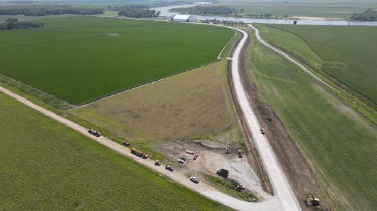
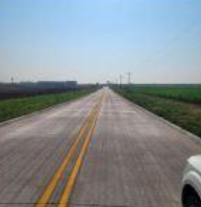
Monona County, Monona County Economic Development Partnership and Siouxland Interstate Metropolitan Planning Council (SIMPCO) hosted a ribbon-cutting ceremony to celebrate the completion of the new Barge Access Road Project on Thursday, June 15, 2023. This project was funded through a U.S. Economic Development Administration (EDA) FY 2020 Public Works and Economic Adjustment Assistance Program ($1 million) and Iowa Department of Transportation (DOT) Revitalize Iowa’s Sound Economy (RISE) Program ($1.2 million).
Federal and state funds assisted in the construction and pavement of the new roadway allowing access to the newly constructed Port of Blencoe, a barge loading and unloading terminal on the Missouri River, which serves as a gateway to the world markets. The completion of this roadway will aid in future economic development activities for Monona County and the Siouxland region.
Bi-State Regional Commission
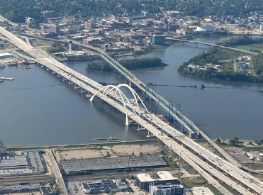
Bi-State Regional Commission's Interstate 74 Bridge Corridor Project benefited the greater Quad Cities Region from Bettendorf, IA to Moline, IL. The number one transportation priority in the Bi-State Region was the replacement of the I-74 Bridge which was adopted as the priority by the Transportation Policy Committee in 1998. It was included in five long range transportation plans developed by the Commission staff. Bi-State worked with the Iowa and Illinois DOT’s and the Federal Highway Administration to implement the project including testifying before the 2003 U.S. Senate Committee on Environment and Public Works and coordination of federal legislative funding request through a unified Bi-State message during the initial years of the project to acquire nearly $100 million dollars.
The $1.4 billion dollar Interstate 74 Bridge Corridor project involved the replacement of the I74 Bridge and over six miles of corridor improvements. The completed I-74 Bridge is the most reliable Mississippi River Crossing between Iowa and Illinois with increased protection for seismic occurrences and barge collisions and was built to last 100 years.
Region XII COG
Region XII COG was awarded 50% regional Transportation Alternatives Program (TAP) grants for Safe Routes to Schools Trail projects to the Cities of Audubon, Denison, and Stuart. COG staff then worked with each city to submit successful statewide TAP applications to the Iowa Department of Transportation to receive an additional 30% grant funding. The partnership between the cities, Region XII COG, and the Iowa DOT provided necessary funding for the construction of walkways and trails which provide safe pedestrian and biker access to and from schools to neighborhoods and community facilities while allowing the RPA to extend regional funding for other projects.
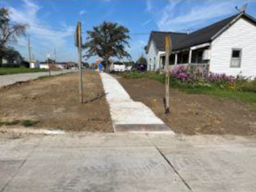
In Audubon, the 3rd Avenue Middle School Rec Central Trail Link was completed in 2022. The NE 2nd Street SRTS Sidewalk project in Stuart was completed in 2023. The Weiss Family Safe Routes to School Trail in Denison has recently started construction.
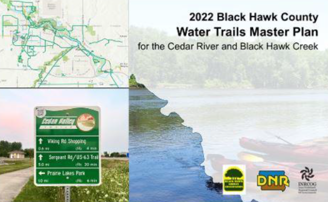
Iowa Northland Regional COG
On September 28, 2022, the Cedar River and Black Hawk Creek were designated as official water trails by the State of Iowa. The water trail journey consists of 47 miles through unique habitats in two major Iowa cities. To view the Water Trails Master Plan, the Water Trails map, paddling safety tips, updates, and more, visit https://cedarvalleywatertrails.com/! This project was made possible with funding from the Department of Natural Resources and the collaboration between the DNR, Black Hawk County Conservation, and local governments.
Iowa Northland Regional COG

In Spring of 2022, INRCOG launched the Interactive Cedar Valley Trails Map. The map showcases over 120 miles of paved trail, on-road bike infrastructure, trail closures, detours and a variety of other features, including bird watching spots thanks to a collaboration with the Prairie Rapids Audubon Society. The map also utilizes a color-blind friendly color scheme! View the map at https://arcg.is/yvGn. The map includes Bremer, Buchanan, Butler, Chickasaw and Grundy counties.
To promote the Interactive Cedar Valley Trail Map, MPO staff designed QR code decals in Spring of 2023. The decals were funded by the Cedar Valley Trails Partnership and installed on all major wayfinding signs throughout the Cedar Valley trail network. The QR codes lead to the interactive map, allowing trail users and community visitors to easily locate the map and utilize its features.
Iowa Northland Regional COG
In an effort to enhance downtown bikeability and safety in downtown Waterloo, MPO staff created 3D conceptual designs for bike lanes on Park Avenue. The new design is currently under review and consists of green colored bike lane surfacing. Once completed, the redesigned bike lanes will accompany bicycle traffic signals and a reconstructed bridge along Park Avenue. An underutilized slip lane in downtown Waterloo sparked conversations about creating a pedestrian and bicycle corridor. With the help of MPO staff, Safe Routes to School, Black Hawk Public Health, Waterloo Complete Streets and various local organizations and non-profits, a design to implement painted crosswalks and posts is under review to expand downtown walkability, bikeability, and safety.
Upper Explorerland Regional Planning Commission
UERPC assisted the City of Decorah in mapping and evaluating walking infrastructure for accessibility and connectivity. Upper Explorerland Regional Planning Commission (UERPC) created a geospatial data framework and geographic information system (GIS) for Decorah’s walking infrastructure. The City contacted UERPC for assistance in better understanding its walking network—sidewalks, multi-use trails, curb ramps, and more—including where facilities are lacking. UERPC designed the GIS to be immediately useful in visualizing the broader walking network and identifying “red zones” where pedestrian infrastructure is especially lacking. The GIS is set up to be “built out” with a plethora of data related to accessibility, asset management, connectivity, and more, as City crews collect field data over time.
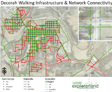
An intern from Luther College’s environmental studies program assisted the City in digitizing features in the GIS. The result of this collaboration is a powerful tool for assessing the accessibility and connectivity of the City’s transportation network and prioritizing projects in furtherance of the City’s sustainability and equity goals.
Metropolitan Planning Agency
MAPA advanced planning for safer streets with local partners.
In August 2022 the MAPA Board of Directors passed a resolution supporting the development of a Comprehensive Safety Action Plan. The resolution calls for achieving zero fatalities and serious injuries on local roads by 2040. The USDOT awarded MAPA $750,000 through the “Safe Streets and Roads for All” grant program to improve traffic safety by developing a safety plan for MAPA's Nebraska communities and the Pottawattamie County cities of Council Bluffs, Carter Lake, Crescent and McClelland.
MAPA also applied this year for a second program grant with Southwest Iowa Planning Council to develop a safety action plan for the counties in Iowa’s Regional Planning Affiliation-18 (eastern Pottawattamie, Mills, Shelby and Harrison Counties). Both plans will identify projects and policies which improve safety on local roads. Development of the MAPA regional Comprehensive Safety Action Plan is expected to get underway in 2024.
Metropolitan Planning Agency
MAPA Secured RISE funds to support Mills County Economic Development.
In 2020, MAPA worked with Mills County to secure $2,525,000 from the county share of the RISE Fund to assist in the paving of approximately 2,400 feet of Applewood Road, construction of approximately 4,100 feet of 182nd Street, passing/turn lanes on County Road H-10 and Bunge Avenue and overlay of approximately 11,700 feet of Bunge Avenue located south of Council Bluffs. This project is necessary to provide improved access to seven lots totaling more than 680 acres for industrial purposes.
Metropolitan Planning Agency
In 2023, MAPA worked with the Lewis Township Fire Department to help them coordinate with Iowa DOT, Pottawattamie County and the City of Council Bluffs for consideration of a traffic signal improvement to the Fire Station near the intersection of IA 92 and Highland Park Drive. The project is moving forward by adding safety beacons as part of the Traffic Safety Improvement Program. Safety funding for this project was $106,237.
East Central Iowa Council of Governments
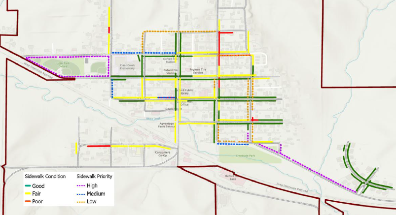
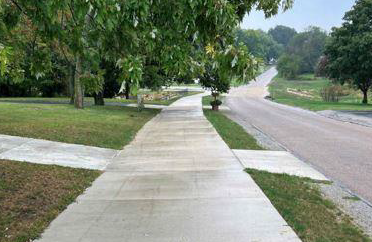
The Region 10 Regional Planning Affiliation (RPA 10), staffed by ECICOG, has undertaken an Active Transportation Plan (ATP) to address non-motorized transportation – primarily walking and biking.
One component of the plan is the development of a sidewalk assessment for each city within RPA 10 (Benton, Cedar, Iowa, Johnson, Jones, Linn, and Washington Counties). The assessment identifies the availability and condition of existing sidewalks. In addition to aiding in the development of the ATP, the assessments have also been used to help communities that are developing comprehensive plans to understand how they might prioritize sidewalk investments to improve walkability.
East Central Intergovernmental Association
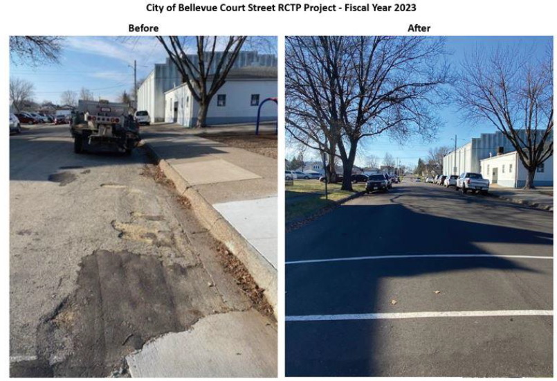
In August 2023, ECIA was awarded a 2023 Excellence in Regional Transportation Award from the National Association of Development Organizations (NADO) for their Rural County Transportation Program (RCTP).
The RCTP provides funding to small cities with less than 5,000 residents to help implement local transportation projects. The program is a partnership between ECIA, Regional Planning Affiliation 8 (RPA 8) and Clinton, Delaware, Dubuque and Jackson counties.
Many small, rural communities have limited street maintenance budgets and have difficulty accessing federal aid funding. Each year RPA 8 allocates $70,000 in additional federal aid to each of the four counties, and in turn, each county sets aside $70,000 in local funding for the RCTP grant program to be awarded to several recipients. RPA 8 administers the program and assists cities with writing applications. Since 2019, the RCTP program has awarded $1.68 million to 83 projects across the four-county area.
East Central Intergovernmental Association
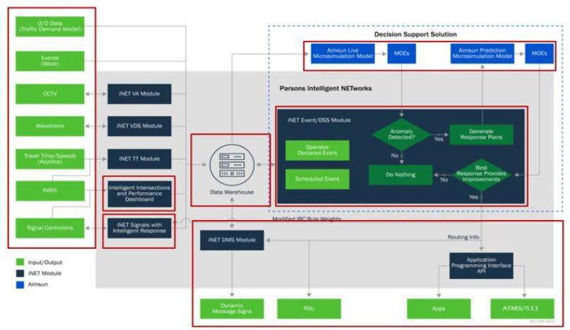
ECIA in partnership with the City of Dubuque, Iowa Department of Transportation and Federal Highway Administration, deployed phase I of the Smart Traffic Routing with Efficient and Effective Traffic Systems (STREETS) project.
The STREETS project aims to provide a better and more balanced utilization of the highway network infrastructure within the Dubuque metro area, through utilization of the existing and new ITS, while also applying strategies to address transportation demand and supply dynamically.
The system includes five major components: (1) Travel Demand Model (TDM); (2) Microsimulation Traffic Model (MTM); (3) Intelligent traffic signal control (4) An automated Decision Support System (DSS); and (5) advanced traveler Information System (ATIS). The system leverages an Aimsun Live model to predict near-future traffic condition horizons (i.e., 15, 30, 45 minutes) for the DSS module. The system models the demands, routing, and traffic into and throughout the Dubuque metro area.
The system provides transportation system users with real-time information that can be used to make decisions about route choices, estimate travel times and avoid congestion. Phase I will be live in March of 2024 and Phase II will follow. Phase I of the STREETS project was awarded $3.4 million.
Southern Iowa Council of Governments
SICOG’s Transportation Board (RPA-14 ATURA) awarded the City of Corning $40,000 in Surface Transportation Block Grant (STBG) & $120,000 in Transportation Improvement Program (TAP) funds for Hull Street Trail.
The trail was created to mitigate safety concerns for pedestrians to access the High School Football Field and walking track from the elementary school. This trail initiates the City’s desire to become a walkable community.
Chariton Valley and Planning Development Council
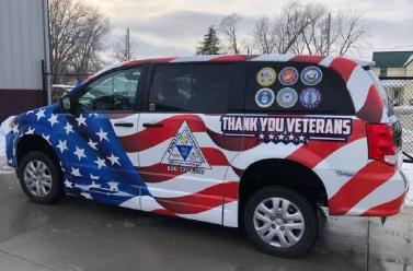
10-15 Transit in Ottumwa, IA has been awarded a 2023 Excellence in Regional Transportation Award from the National Association of Development Organizations (NADO) for their Veteran’s Transport project.
This project acknowledges that living in rural Iowa can make it difficult to access the high-quality Veterans medical care they deserve. Although there may be many obstacles prohibiting Veteran’s from obtaining medical care, distance and transportation are citied as being the most common challenge greater health care needs and lower health-related quality-of-life scores compared with urban veterans. Chariton Valley Transportation Planning Affiliation (RPA 17), 10-15 Transit and the local Veteran’s Affairs offices of Appanoose, Wayne & Lucas Counties launched a transportation initiative in 2019 (FY 2020) to improve veteran’s access to health care.
Southeast Iowa Regional Planning Commission
The Safe Streets and Roads 4 All (SS4A) grant program is a $5 billion initiative established in the Bipartisan Infrastructure Law to fund regional and local efforts to prevent traffic deaths and serious injuries.
Southeast Iowa Regional Planning Commission received $64,000 in SS4A action plan grant funding in August 2023 to create their Comprehensive Safety Action Plan (CSAP). S
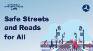
SEIRPC’s CSAP aims to analyze key road network safety issues within incorporated cities in RPA 16. The development of this safe systems approach encompasses all transportation modes and is aligned with the FHWA’s Vision Zero campaign to eliminate fatal accidents on our roadways. A SS4A Action Plan, or other preexisting CSAPs, is a prerequisite for SS4A Implementation Grant applications – which SEIRPC will seek after identifying critical safety priorities in our cities’ respective road networks.
Southeast Iowa Regional Planning Commission
In the fall of 2021, SEIRPC assisted the City of Mount Pleasant with a local development RISE grant to support the relocation and expansion of a local business, Mid Am Products and to open an additional 44 acres in the Crossroads business park for development.
SEIRPC was able to secure $254,802 from the city share of the RISE Fund to assist in the paving of approximately 1,545 feet of Bluegrass Road. The road project was completed during the summer of 2023 with Mid Am Products expansion project currently under construction with plans to be open in early 2024.
Region 6 Resource Partners
The Region 6 Resource Partners has helped Hardin County and the City of Marshalltown develop the 34-mile Iowa River’s Edge Trail Rail to Trail conversion project. The City of Marshalltown owns the 14 miles of trail within the City of Marshalltown and Marshall County.
The first 2.8 miles of that trail has been developed at the southern end (paved and bridges rehabilitated), starting in the middle of Marshalltown. The northern 5 miles of trail has also been completed (paved and bridges rehabilitated) from Steamboat Rock to Eldora. Region 6 has played a critical role with securing and administering more than 12 grants for the project. The project construction cost has been about $4 million and acquisition cost from Iowa River Railroad near $1 million.
Partnering with other state and local groups has been a key to the success. This includes the Iowa Natural Heritage Foundation, local governments, trail groups, and funding sources.